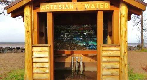
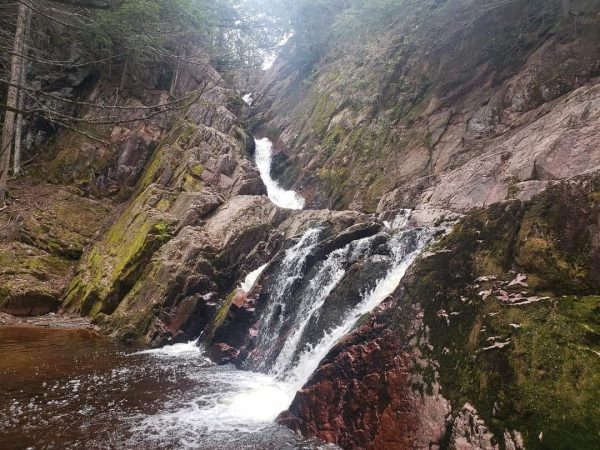
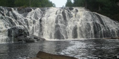
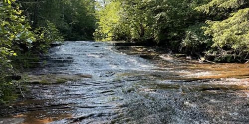
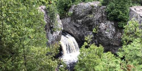
Skip to content Skip to main navigation Skip to footer

Copper Falls State Park – 300 Points

Ancient lava flows, deep gorges and spectacular waterfalls make Copper Falls State Park one of Wisconsin’s most scenic parks. Log buildings built by the Civilian Conservation Corps in the 1930s add to the park’s charm. The park offers camping, hiking, bicycling, picnicking, fishing and swimming opportunities in Loon Lake. The 1.7-mile Doughboy’s Nature Trail, along the Bad River, is one of the best hikes in Wisconsin. Copper Falls is located 30 miles south of Ashland on Hwy 169 just off of Hwy 13.

Spring, summer, fall and winter…..
Ashland County is a year-round vacation destination for nature enthusiasts and silent sports fans. No matter the season Northern Wisconsin’s Waterfalls are always open. Ashland County cordially welcomes visitors to enjoy and explore this shining jewel crowning the greatest of the Great Lakes.

Ever want to just get out and enjoy nature? Waterfalls and Waterways Trail Pass helps you do that! You can Explore the Chequamegon Bay and win cool prizes while you do it!

Here is how it works:
When you are visiting the Waterfall or Waterways take a photo of you or your group enjoying the views.  Each Waterfall and Waterways has points associated with them.  Email us the photos, collect points and win prizes.

  • Collect 800 points and receive an Ashland-Find Yourself next to the Water sticker
  • Collect 1600 points get an Ashland – Find Yourself next to the Water hat
  • Collect 2700 points get an Ashland – Find Yourself next to the Water t-shirt.

Spend a few days in Ashland, where you’ll find yourself, Next to the Water

Diving Board into Lake Superior Bayview Beach – 300 Points

Where else can you DIVE into Lake Superior? Best view of Ashland’s Breakwater Lighthouse! Swimming beach, diving board, bathrooms, fishing pier, picnic area and playground. At Bayview Park, you can catch the Waterfront Trail, a Walking/Biking Trail that circles the City of Ashland.

Ed Griffiths Pedestrian Pass Tunnel – 300 Points

A Mosaic mural located inside of the Ed Griffiths Pedestrian Pass, a tunnel under Hwy 2/Lake Shore Drive and provides a passage from Pearson Plaza to Ashland’s Waterfront Trail, a Walking/Biking Trail that circles the City of Ashland. Look for the scavenger hunt on the mural wall. The landscape mosaic/mural hybrid spans the entire length of the underpass – 3,684 square feet – and highlights the ecology of the region. A Community Project. You can access the tunnel by the 6th Ave West Beach or behind City Hall 601 Main Street West.

Houghton Falls Nature Preserve – 300 Points

Houghton Falls protects a picturesque pre-Cambrian sandstone gorge along the Lake Superior shore. The dramatic sandstone cliffs extend into the clear waters of Lake Superior, affording views of the Apostle Islands. The gorge is shaded by second-growth hemlock, yellow birch, white cedar, along with a few, large white pine. The .75 mile trail traverses some beautiful natural features before ending at the edge of Lake Superior – far above the water. The waterfall flow is seasonal. Please note that the gate in the parking area will lock automatically at the posted closing time. Located 3.5 miles north of Washburn. Turn on Houghton Falls Road and drive .5 miles to the parking area.

Lost Creek Falls – 300 Points

Lost Creek Falls is a very scenic waterfall located in the woods south west of Cornucopia. The falls consists of an 8′ plunge with a few feet of cascades above and below the plunge. You can walk behind the falls, which is not common for waterfalls around Lake Superior. There is a small 3′ cascade a short distance downstream of the main waterfall. Reached by a 2-mile hike scenic walk through the woods to the waterfall. Just south of Cornucopia. 17.4 miles north of Washburn on Cty. Hwy C, turn on Trail Drive and travel .5 miles to the parking area/trailhead. Follow the signs 1.5 miles through the forest to the falls. The trail is well-marked and improved with boardwalks and gravel.

Maslowski Beach Artesian Well – 300 Points

FYOB (fill your own bottle)! Come to Maslowski Beach where you can fill your own bottle with clear, clean, fresh artesian water 24 hours a day! Maslowski Beach offers a shallow, sandy swimming beach, playground, pavilion, bathrooms, changing rooms and artesian well. Easy access to Ashland’s beautiful Waterfront Trail along Chequamegon Bay, a Walking/Biking Trail that circles the City of Ashland. Great place to view Ashland sunsets.

Morgan Falls – 300 Points

This recreation area features two popular trails – one leading to the 70-foot high Morgan Falls and the other to a scenic overlook at the top of St. Peter’s Dome. Morgan Falls is 80-100 feet high. The trail to Morgan Falls features an accessible trail with boardwalk and bridge that is nearly .75 miles one-way. The trail to St. Peter’s Dome is nearly 2 miles one-way and is fairly rugged with exposed rocks and steep slopes. From the top, is a breathtaking view of Chequamegon Bay of Lake Superior and the Apostle Islands. From Ashland, go south on State Hwy. 112 /Sanborn Avenue, follow for about 9 miles. Go straight onto County Hwy. E into the town of Sanborn. Go about 1.5 miles past Sanborn. Turn left onto Ashland-Bayfield Rd. Follow south for about 4 miles, the parking area and trailhead will be on the left.

Ore Dock – 300 Points

The Ashland Ore Dock, which was built in 1916, was a monumental structure and measured out at 1,800 feet. It was the largest concrete dock in the world. The base remains and the city is working on making it a fishing pier. Currently, only the first half of the dock is open to the public. At the Ore Dock you can catch the Waterfront Trail, a Walking/Biking Trail that circles the City of Ashland.

Potato River Falls – 400 Points

One of the most beautiful falls in the Midwest. Drops 90 feet into the Potato River southwest of Gurney. A Town Park with rustic campsites and a picnic area is available. There are upper and lower falls. From the parking area you can choose to hike to one or both of the two lookouts to view the Potato River Falls. The trail to the right is labeled with a sign “Lower Falls” and includes a series of 204 steps to reach the observation deck. The trail to the left from the parking area is labeled with a sign “Upper Falls”. This takes along the gorge and down 131 steps to the lookout for the Upper Falls. Travel south from U.S. Hwy. 2 on State Hwy. 169, 2.8 miles through the Town of Gurney. Turn west on Potato Falls Road, continue 1.5.

Prentice Park Artesian Well – 300 Points

Prentice Park is one of the “jewels” of the City’s park system with an artesian well, 2+ miles of ADA trail, playground, pavilions, and easy access to US Hwy 2 and Lake Superior, which connects you to the Waterfront Trail, a Walking/Biking Trail that circles the City of Ashland. Prentice Park offering 6 primitive sites and 7 RV sites with onsite water & electricity. The park also has a shower house and restrooms.

Siskiwit Falls – 300 Points

Siskiwit Falls is located in the town of Cornucopia on the Siskiwit River, less than a mile before it empties into Lake Superior. The falls consist of a series of drops and slides. On the Siskiwit River located .25 miles east of Cornucopia off Cty. Hwy. C on Siskiwit Falls Road. Please follow signage and respect private landowners. There are more falls downstream on the north side of the road, currently accessible only by an unimproved foot worn trail (less than .25 mile)

Wren Falls – 300 Points

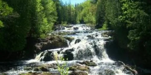
Wren Falls is located on the Tyler Forks, a tributary of the Bad River. The Bad River is aptly named, as it and its tributaries have carved rocky, twisted and often deep gorges through northern Wisconsin on its way to Lake Superior. The falls is only 12′ high at most, but the deep gorge it slides into is very impressive, and the dramatic view from the overlook seems to make the falls look much bigger than it actually is. Reaching the falls is straightforward, especially if you have an ATV or a high clearance vehicle. For those of us with less rugged vehicles, you may need to hike about 1.5 miles to reach the falls. From Highway 169 take a right onto Vogues Road. Vogues road is a wide, well maintained dirt road. Follow Vogues Road for 3.6 miles. It does a big arc, and ends at a hairpin turn where it meets Casey Sag Road. At this point you will be heading west. Casey Sag Road continues west as a rough two track. Another two track heads south. This is the road, or perhaps more accurately the trail, to Wren Falls. You could take a car or truck down it, but it is only wide enough for one vehicle, and there is no room to pass, and little room to pull off. People take ATVs down the trail, mountain bikes, but hiking is the most common.

While you are here, why not check out our Mural Trail Adventure
“Ashland Mural Adventure” ?…..

For more information contact Ashland County Tourism.  715-682-2500 or info@visitashland.com